The project

Against the flow

Upstream tidal transport and trapping of spilled plastic pellets in the River Tyne.

Background

On 19 July 2026 a vessel collision at the Port of Tyne released about 17 tonnes, roughly 850 million pellets, of pre-production high-density polyethylene (HDPE) into the River Tyne. It is the largest documented sudden release of plastic pellets directly into a European river or tidal estuary.

Pellets like these persist in the environment and spread widely. Animals can swallow them, and they can pick up contaminants from the surrounding water and sediment. The tidal Tyne also carries unusually high concentrations of metals such as zinc, cadmium and lead, much of it from historic mines upstream.

Conditions on the day favoured upstream movement: the spill came just before low water, followed by a 4.62 m high tide, a 5 m/s up-estuary wind, and exceptionally low river flow. No previous study has measured how far a known pellet spill penetrates up a macrotidal river, or where it is first stored.

Why now

The known source, timing and initially "virgin" condition of the pellets give a baseline that cannot be recreated once the material has been exported, buried, colonised by organisms, broken up or removed. Those changes are already under way. Pellets stored on mudflats, among riverside vegetation and along strandlines can be picked up again by spring tides or high river flows. They could then become a delayed source of pollution to the lower river and coast long after the initial clean-up has ended.
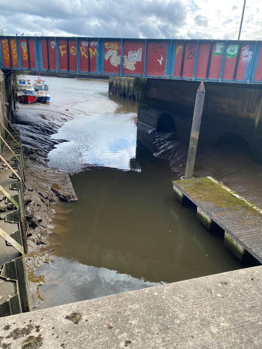
Low tide at the mouth of the Ouseburn, a tributary of the Tyne in Newcastle, showing exposed mudbanks beneath a railway bridge with small boats moored nearby.
Exposed mud at the Ouseburn mouth, July 2026. Intertidal mudbanks like these can trap floating pellets as the tide falls.

Study area

The tidal Tyne, from the river mouth at North Shields and South Shields upstream past Newcastle and Gateshead towards Wylam.

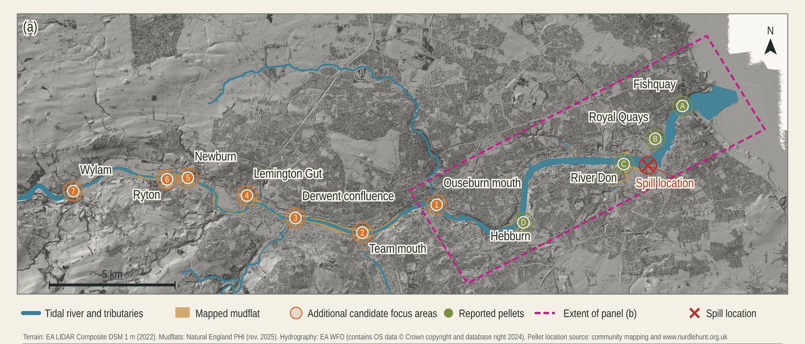
Map of the tidal River Tyne from Wylam in the west to the river mouth in the east. It marks the spill location near the River Don, sites where pellets have been reported (Fish Quay, Royal Quays, River Don and Hebburn), and seven candidate focus areas upstream including the Ouseburn mouth, Team mouth, Derwent confluence, Lemington Gut, Newburn, Ryton and Wylam.
The tidal Tyne, showing the spill location, early pellet reports and candidate focus areas for surveys. Terrain: EA LIDAR Composite DSM 1 m (2022). Mudflats: Natural England Priority Habitat Inventory (2025). Hydrography: EA WFD, contains OS data © Crown copyright and database right 2024. Pellet reports: community mapping and nurdlehunt.org.uk.

Objectives

  1. Establish the upstream limit and spatial pattern of pellet deposition from the spill.
  2. Quantify flood-tide and ebb-tide pellet transport through full tidal-cycle observations.
  3. Identify the controls on pellet dispersion and retention using 3D hydrodynamic modelling.
  4. Examine how the pellets change over time through breakdown, biofouling and trace-metal uptake.

Work packages

WP1

Spatial dispersion

Lead: Matthew Perks. Co-lead: Louise Callard.

We combine dated public observations, photographs and clean-up records with low-tide surveys of mudflats, riverside vegetation and strandlines, working with Groundwork NE & Cumbria. Low-altitude drone surveys produce sub-centimetre imagery for detecting pellets, and lidar maps the ground surface. Surveys are repeated after spring tides and high flows. Surface samples and sediment cores show whether pellets are present in and beneath the riverbed.

WP2

Transport and remobilisation

Lead: Matthew Perks. Co-lead: Seb Pitman.

Over six campaigns, paired manta nets towed from a station-keeping boat measure pellets moving near the water surface across complete tidal cycles at stations along the river. Recording flow velocity and the volume of water filtered lets us calculate the balance between upstream and downstream transport. Extra rapid-response surveys after high river flows show whether floods flush stored pellets seaward.

WP3

Hydrodynamic controls

Lead: Seb Pitman. Co-lead: Christopher Hackney.

A 3D hydrodynamic and particle-tracking model of the tidal Tyne, forced by measured tides, river flow and wind, reconstructs the 19 July release and predicts pathways and deposition hotspots. Ensemble runs across different flows, tides and winds show what controls how far pellets travel upstream, where they are retained, and when they are released. Where bathymetry data are lacking, we survey the riverbed with a multibeam echosounder.

WP4

Microplastic characterisation

Lead: Annie Ockelford. Co-lead: Adam Jarvis.

Recovered particles are confirmed as spill material using infrared spectroscopy (ATR-FTIR) and microscopy. We track changes in surface structure, biofouling, surface chemistry (SEM-EDS) and how fast pellets rise in water. We also measure how zinc, cadmium and lead attach to the pellets over time, and compare this with metal concentrations in the surrounding water and sediment.

Expected outcomes

  • An integrated picture of where the spilled pellets travelled, and where they are stored, across the tidal Tyne.
  • Identification of sites that could release pellets again in future, to guide monitoring and clean-up.
  • Evidence to inform the next phase of the regional response and recovery.
  • Methods and predictive understanding that can be used in response to future microplastic spills in tidal rivers and estuaries worldwide.

Open research

We follow the FAIR principles, making data Findable, Accessible, Interoperable and Reusable. Research datasets will be deposited with a NERC Environmental Data Service data centre. Observations from the public are only ever shared in aggregated or anonymised form. See our privacy notice.

Publications, datasets and presentations